UPDATE: At 9 p.m., the National Weather Service revised its estimates for river levels once again, this time placing all cities in the region in at least minor flood status.
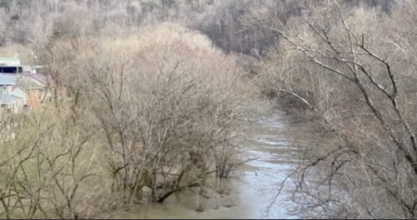
It is important to note that the estimates are for river flooding only, not for flash flooding, which has been severe in many areas of Eastern Kentucky, covering roads, damaging many structures and sending first responders out to rescue countless people trapped by rising water.
MODERATE FLOODING
Pikeville has now joined Paintsville as the only two communities currently projected to be in moderate flood status. The WPS defines moderate flooding as “Some inundation of structures and roads near streams.”
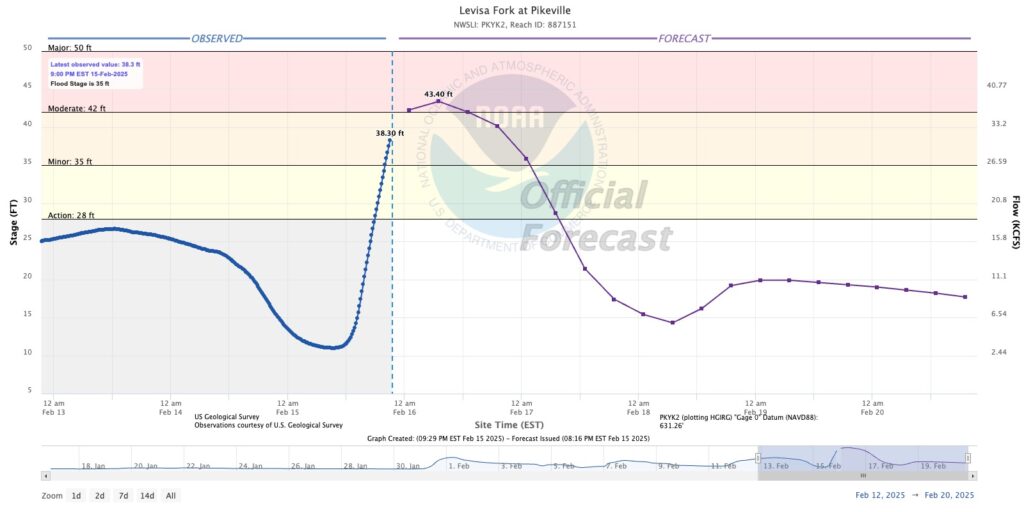
Pikeville has already reached minor flood and is expected to crest at 43.4 feet around 7 a.m., Sunday. That places it 1.4 feet above moderate flood stage, but still well shy of major flood status, which is 50 feet.
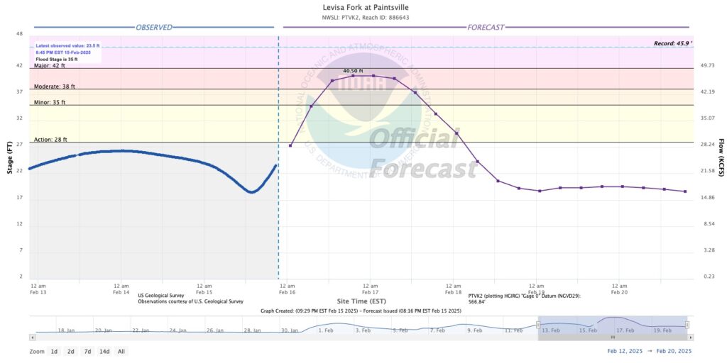
Paintsville is expected to crest at 40.5 feet at 7 p.m., Sunday, and remain there for six hours. That level which is 2.5 feet above moderate level, but still 1.5 feet short of major flooding.
MINOR FLOODING
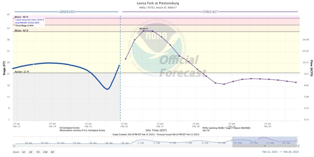
The rest of the region is currently projected to reach minor flood status, with Prestonsburg the last city to make that list. Prestonsburg is expected to crest at 40.4 feet around 1 p.m., Sunday — just five inches above minor flood level. The river is expected to remain around that same level until around 7 p.m.
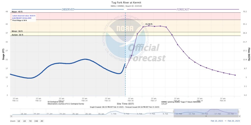
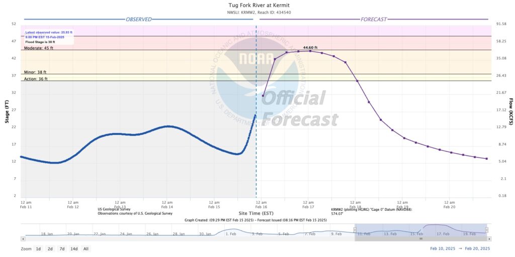
Kermit is now expected to flirt with moderate status, reaching a crest of 44.6 feet around 1 a.m., Monday, just five inches shy of moderate flood status.
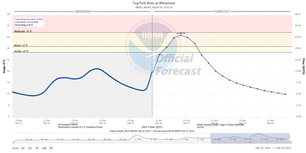
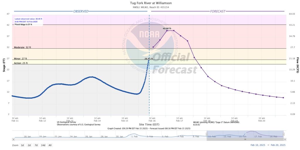
Williamson is expected to see river levels reach 40 feet at 1 p.m., Sunday, and stay there until 7 p.m. That is 2.7 feet below moderate flooding.
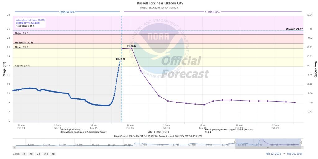
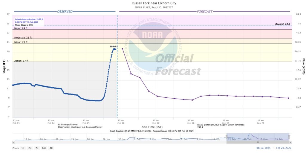
Elkhorn City was initially projected to reach 21 feet, which is the level where minor flooding begins. The current model does not show it reaching that level, but there is a gap in the graph. The Russell Fork was at 19.65 feet at 8:30 p.m.
Copies of river projections follow:
ORIGINAL STORY: PIKEVILLE, Ky. — Saturday’s rain has been somewhat heavier than had been expected 24 hours earlier, leading the National Weather Service to increase its estimates for river levels over the next 48 hours.
As a result, the NWS’s Water Prediction Service now places Pikeville in the minor flood category and raises expected levels around the region. However, as had been forecast earlier, no towns in the Big Sandy region are expected to receive major flooding.
It is important to note that the estimates are for river flooding only, not for flash flooding, which has been severe in many areas of Eastern Kentucky, covering roads, damaging many structures and sending first responders out to rescue countless people trapped by rising water.
MODERATE FLOODING
Only one community in the Big Sandy Valley is currently expected to see water levels rise into the moderate category. The WPS defines moderate flooding as “Some inundation of structures and roads near streams.”
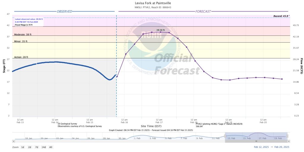
Paintsville is expected to see river levels rise to moderate flooding levels around 1 p.m., Sunday, and crest at 39.5 feet at 1 a.m., Monday, which is 1.5 feet above moderate level, but still 2.5 feet short of major flooding.
MINOR FLOODING
Many communities around the region are expected to see river levels rise to the minor flooding level. The WPS defines minor flooding as, “Minimal or no property damage, but possibly some public threat.”
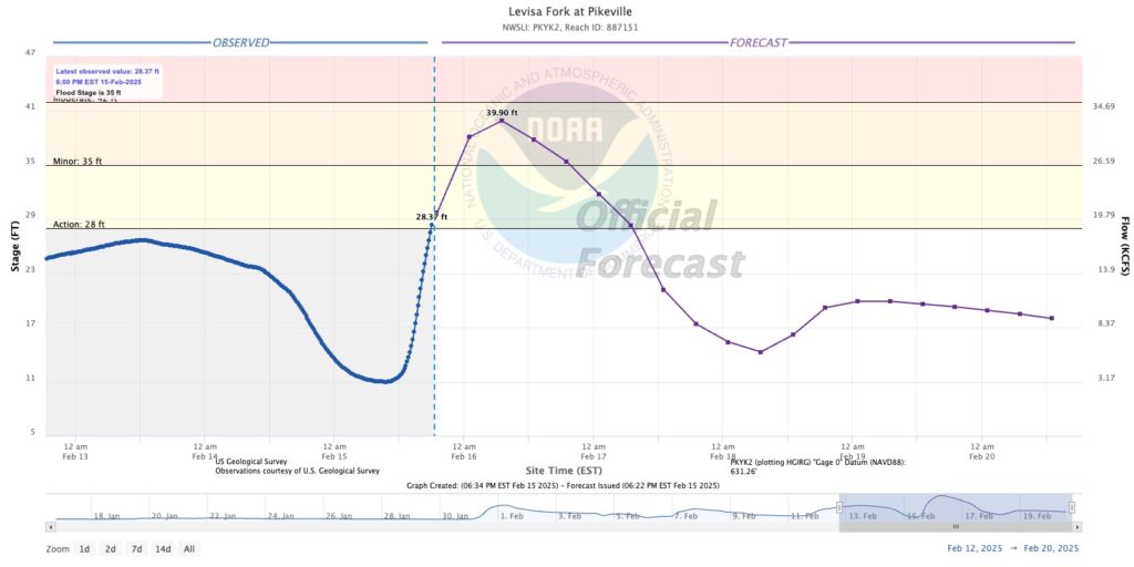
Pikeville is now expected to see river levels rise to 39.9 feet at 7 a.m., Sunday, which is nearly five feet above minor flooding, but two feet short of major flooding.
Elkhorn City is expected to see river levels reach 21 feet at 1 a.m., Sunday, which is the level considered to be when minor flooding begins, while moderate flooding begins at 22 feet.
Williamson is expected to see river levels reach 31 feet at 7 p.m., Sunday, which is four feet over minor flooding but one foot short of moderate flooding.
Kermit is expected to see river levels reach 41.5 feet at 7 p.m., Sunday, which is 3.5 feet above minor flooding and 3.5 feet below moderate flooding. Unlike most areas, which can expect water levels to begin dropping shortly after cresting, the water levels are expected to remain at about the same level for 12 hours.
ACTION STAGE
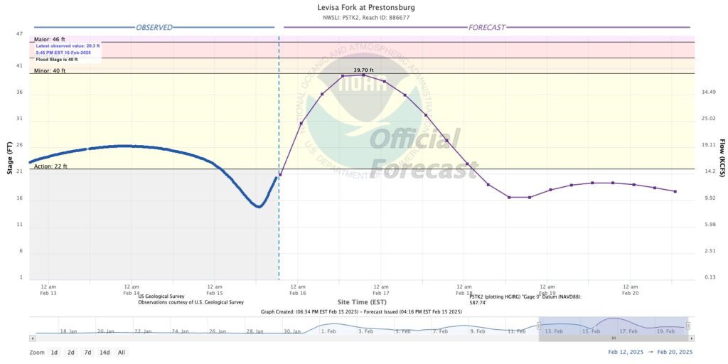
Prestonsburg is the only community in the region currently not expected to reach flood stage, but only by about three or four inches. The river is expected to crest at 39.7 feet at 7 p.m., Sunday, just 0.3 feet short of minor flooding stage.
Water levels are expected to reach the “action stage” in Prestonsburg, which is the WPS’s lowest category and is defined as, “The level which, when reached by a rising stream, represents the level where the NWS or a customer/partner needs to take some type of mitigation action in preparation for possible significant hydrologic activity.”
FULL FORECASTS
Copies of the full reports for each community follow: